Hiking & Waterfalls
:Nestled in the heart of the stunning Appalachian Mountains, Lake Glenville offers more than just a serene escape for boaters and anglers—it’s a dream destination for hikers and nature enthusiasts alike. Whether you're an experienced adventurer or a family looking to create lasting memories in the great outdoors, Lake Glenville boasts a variety of hiking trails suitable for all skill levels.
Winding through lush forests, these trails offer breathtaking vistas and paths that lead to some of the most beautiful landscapes in Western North Carolina. From panoramic views of the lake and surrounding peaks to peaceful forest paths, every step on these trails brings new opportunities for awe and adventure
But Lake Glenville is only part of the story. The Sapphire, Cashiers, and Highlands areas—collectively known as the Land of Waterfalls—are home to over 200 mesmerizing waterfalls. This region is famous not just for its waterfalls but also for its extraordinary hiking opportunities, which range from easy strolls to expert-level challenges. Whether you’re looking to explore hidden cascades or enjoy a relaxing day in cool, shaded forests, the trails here offer something for everyone.
As we continue to uncover new waterfalls and hiking opportunities in the area, this page is always evolving. So be sure to check back often and stay updated on the latest discoveries!
For the most up-to-date information on hikes and waterfalls, don’t forget to download the AllTrails App—available for free on your phone. It provides comprehensive details about each trail, including difficulty levels, distance, and current trail conditions, ensuring you have everything you need for a safe and memorable adventure.
Start your journey today, and let Lake Glenville and the Land of Waterfalls captivate your heart and soul.
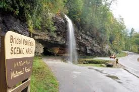
Bridal Veil Falls, Franklin/Highlands
Bridal Veil Falls is a fun walk to the 120-foot waterfall, which is located about 2.5 miles west of Highlands on Hwy 64. It is on a tributary of the Cullasaja River. There is a little loop off the highway so you can drive right under the falls, but will sneak up on you. If you miss it, pull off after the waterfall in the wide area on the right and park or circle back around.
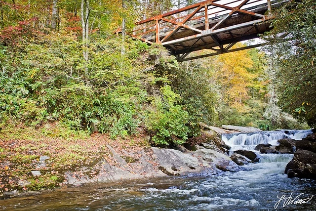
Bull Pen Falls, Cashiers
Bull Pen is as much rapid as waterfall. While not the most dramatic falls in the area, this is a great place to hang out for a while and explore the Chattooga River Trail. (Credit GoCashiers) However, white water rafting, canoeing, and kayaking is prohibited in this section of the Chattooga. The falls can be easily viewed at the bridge or you can take a short trail just past the west side of the bridge to the top of the cascade. At the bottom of the cascade, the powerful Chattooga has carved deep swirl-holes in the rock. Over thousands of years, small pebbles and grains of sand were swirled around by the water to create these holes. Several hiking trails are in the area, including a new loop trail that follows the river upstream. Plus, this is a popular spot for fly fishing.
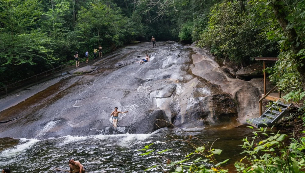
Quarry Falls, or, "Bust Your Butt Falls", Sapphire
A popular swimming and sliding area along U.S. Highway 64 is "Bust Your Butt Falls" (also known as Quarry Falls or Bust-Yer-Butt Falls). For added excitement, there is a "jump off" rock for diving into the chilly waters. It's six miles west of Highlands on U.S. 64 (about 3 miles from Dry Falls). (Courtesy Romantic Asheville)
Cullasaja Falls, Franklin/Highlands
Big falls at 250ft and considered to be one of the most picturesque falls in western North Carolina. This fall is the first seen from U.S. 64/28. The falls are spectacular and this wavy strip of U.S. 64/28 is a paved marvel of highway. A real hang onto your hat kind of road but well worth the drive. Directions: Located on U.S. 64/28 between Highlands and Franklin
Lower Cullasaja Falls
The lower portion of Cullasaja Falls is a cascade of water which flows about 250 ft down. It is located on the Cullasaja River at the lower part of the Cullasaja Gorge. It is part of the Mountain Water Scenic Byway. Cullasaja Falls is only visible from your car; there is no adequate pull-off from the road. Directions: Cullasaja is located off U.S. 64, 11 miles east of Franklin, 9 miles west of Highlands in the Cullasaja Gorge.
Drift Falls, Cashiers
This waterfall is somewhere around 80 feet long. It doesn't drop straight down like a traditional waterfall, but instead slides at close to a 45-degree grade. This waterfall can be used as a water slide by the brave and hard-headed. From Cashiers follow US-64 10 miles east to Sapphire. Turn right on the 'Whitewater' Road and then south about 3 miles to the Horsepasture River.
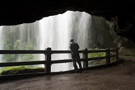
Dry Falls, Highlands
Dry Falls is in the Nantahala National Forest. You can see it from the road and no, it's not dry! There is an old log shelter at the trail-head. A lot of water pours over this wide waterfall. There is a well maintained path that leads a short distance down from the parking area. The path doesn't end at the falls but travels under the falls. It's a breath taking experience to stand under the falls and watch millions of gallons of clear mountain water pour over your head and before your eyes at a height of 75 ft. Directions: On U.S. 64/28 four miles from Highlands.
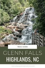
Glen Falls, Highlands
Glen Falls is a must see. This is a favorite and probably one of the most beautiful waterfall setting in the Highlands area! It's a great hike and I always like to take a back pack with sandwiches and snacks! Glen Falls is on the east fork of Overflow Creek in the scenic Blue Valley area in Nantahala National Forest. The hike is down hill from the parking lot, so it's quite a climb
to return. There are quite a few switchbacks, so the climb is not too steep. As you descend, you will reach a beautiful view from the top of Glen Falls .Continue down hill to the upper section of the waterfall, dropping about 70 feet. There is plenty of room to rest and relax on the rocks at the base of the falls and maybe have a picnic. Continue about 1/3 mile to the middle section of the falls that drop 60 feet, with water stair-stepping down a wide rock face.
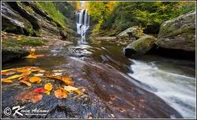
Frolictown Falls, Panthertown Cashiers
Frolictown Falls is a small but nice waterfall in Panthertown Valley. Hiking in this area, you really get the feel of being in the woods. There are no panoramas from this thickly vegetated valley floor. Be sure to get a map of Panthertown Valley or find someone to lead you, as the trails can be tricky.
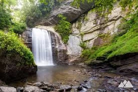
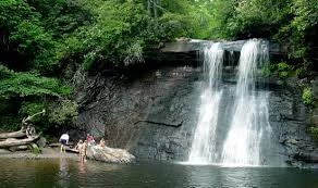
Lookingglass Falls, Pisgah Forest
A beautiful waterfall along an incredible forest drive in Pisgah. This is an easy waterfall to get to without any hiking needed. Just pull over along the street (plenty of easy parking) and walk up to the huge mountain face that bears a cascading waterfall, Lookingglass.
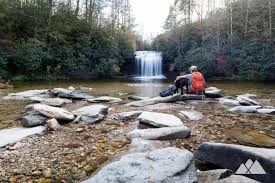
The Narrows, Sapphire
The beautiful Narrows waterfall is located on the Horsepasture River in Sapphire Valley.
Enjoy the scenic trails that lead you to different sections of the river!
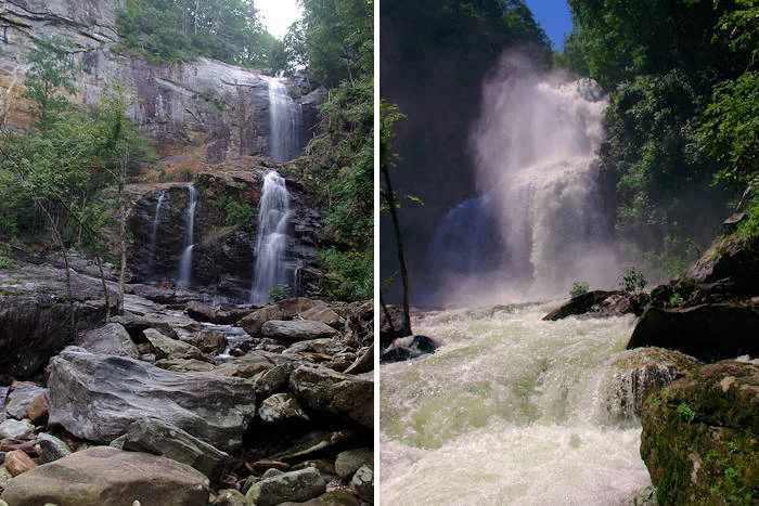
Rainbow Falls, Sapphire
Rainbow Falls is one of the most spectacular waterfall settings in the Blue Ridge Mountains of North Carolina. This 150-foot tall waterfall is impressive, especially after rainy weather that swells the Horsepasture River, its source. The best feature of Rainbow Falls is the ability for visitors to experience the falls from the front, bottom, side, and top! (courtesy Romantic Asheville)

Schoolhouse Falls, Panthertown Cashiers
Among the many hikes and waterfalls in Panthertown, Schoolhouse Falls is one of our favorites. This moderately easy hike takes you to a beautiful waterfall cascading into a swimming cove. This is a great spot to bring a picnic and relax in the sun.
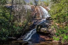
Silver Run Falls, Cashiers
Just moments from Sapphire, a few miles South on 107. A short and enjoyable hike, where you even get to cross a tree fallen across the creek. Very easy walk with a picturesque finale.
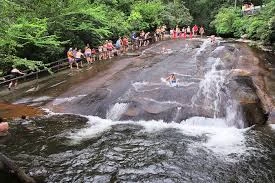
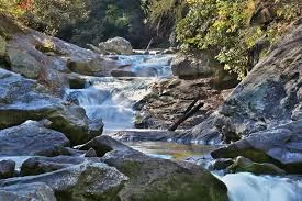
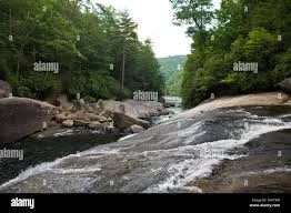
Sliding Rock Falls, Pisgah Forest
Sliding Rock is a natural water slide, created by the Chattooga River gliding over a 10-foot high rock face with a few large potholes. It's a popular local spot during the summer because the water is quite cool. You can slide down the rock, cannonball into one of the potholes or just wade in the pool below the rock.
Turtleback Falls, Sapphire
These falls offer a 20-foot drop over a curved rock face into a pool that can have strong currents. At lower water levels, it's a popular spot to go sliding and swimming. You should be a good swimmer, since there are no lifeguards. The rocks and currents can make it dangerous if inexperienced. Do not attempt to slide when water is high, since the rushing water can take you down river over Rainbow Falls (150 ft drop so do not get too close!). There are several great vantage points to enjoy the falls - and the people sliding. (courtesy Romantic Asheville)
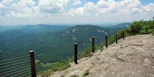
Whiteside Mountain, Highlands
A landmark in the Nantahala National Forest, the Whiteside hike rises to an elevation of 4,930 feet, located between Cashiers and Highlands. A loop trail takes you on top of sheer 750-foot high cliffs with incredible views (from the safety of railings of course). This hike is a favorite of ours.
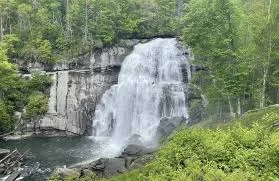
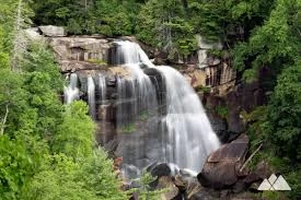
Whitewater Falls, Cashiers
These falls are awesome! This is the highest set of falls east of the Rocky Mountains having a total drop of almost 700 feet. Upper Whitewater Falls plunge an amazing 411 feet! South Carolina's Lower Whitewater Falls drops another 400 feet. In the cool, moist shade of steep slopes and rock cliffs, wildflowers and salamanders are plentiful. Also enjoy the beauty of berries and blooms throughout the seasons.
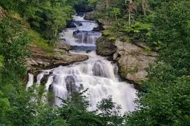
High Falls at Lake Glenville
This is the tale of two waterfalls. High Falls (or Cullowhee Falls) is located just below the dam for Lake Glenville on the West Fork Tuckasegee River near Cashiers in Jackson County. It becomes the most powerful waterfall in the North Carolina mountains for several days each year when extra water is released from the dam for whitewater kayakers. At other times, the water flow increases after heavy rain.
Cashiers Sliding Rock
Near Cashiers is another "Sliding Rock", created by the Chattooga River gliding over a 10-foot high rock face. It's a popular local spot during the summer because the water is quite cool. You can slide down the rock, cannonball into one of the potholes or just wade in the pool below the rock.